Ordnance Survey have announced that they're withdrawing the OS OpenSpace API and
none of the websites used by the script files here now work. It does not
look like any of them are going to update to Ordnance Survey's latest API.
When you open any of the websites listed here you get a 'API Key has been
blocked by Administrator' message or the website has been removed by the author.
If you want to look at classic OS maps then your options are now very limitted.
The OS developers website has some example code and map pages. This one gives a
classic map -
https://labs.os.uk/public/os-data-hub-examples/dist/os-maps-api/leaflet-zxy-27700-basic-map.php?auth=
. You don't need to be a developer to use the webpage, just go to the
URL and you get a full page map. There are examples with different map
styles. Go to
https://labs.os.uk/public/os-data-hub-examples/ look at an example
webpage and then click on the Open link to run the example.
I have a .zip file of Firefox bookmarks here. This is really for use when you boot off a UBuntu DVD although you can import into the desktop version of Firefox if you want. Be careful not to restore into your desktop version because that will wipe your existing bookmarks but if you use the import from HTML option that will just add the bookmarks to your existing ones. Ubuntu version 16.04.7 is a good one to use.
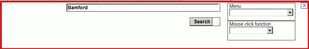
The XP version includes both a small Google map and an Ordnance Survey map. The Google map search functions are used and the results are used to center both maps. You can search for a place name, postcode or a latitude,longitude comma seperated pair. A latitude,longitude comma seperated pair looks like this '51.482252, -0.604248'. When using place names you may need to add ',uk' at the end, e.g. 'Reading, UK'. Having both maps works well.
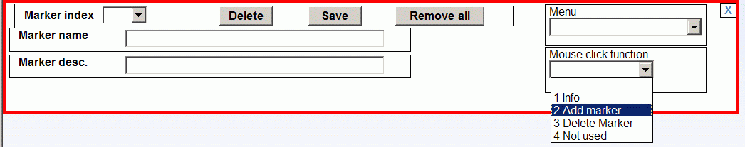
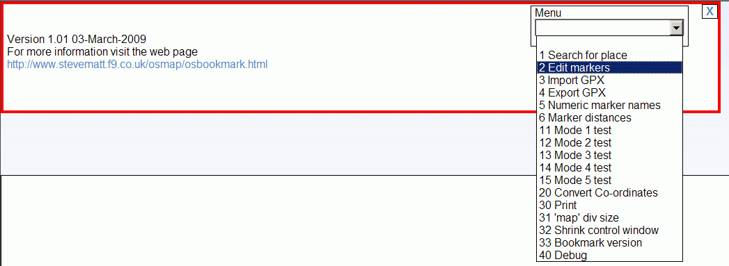
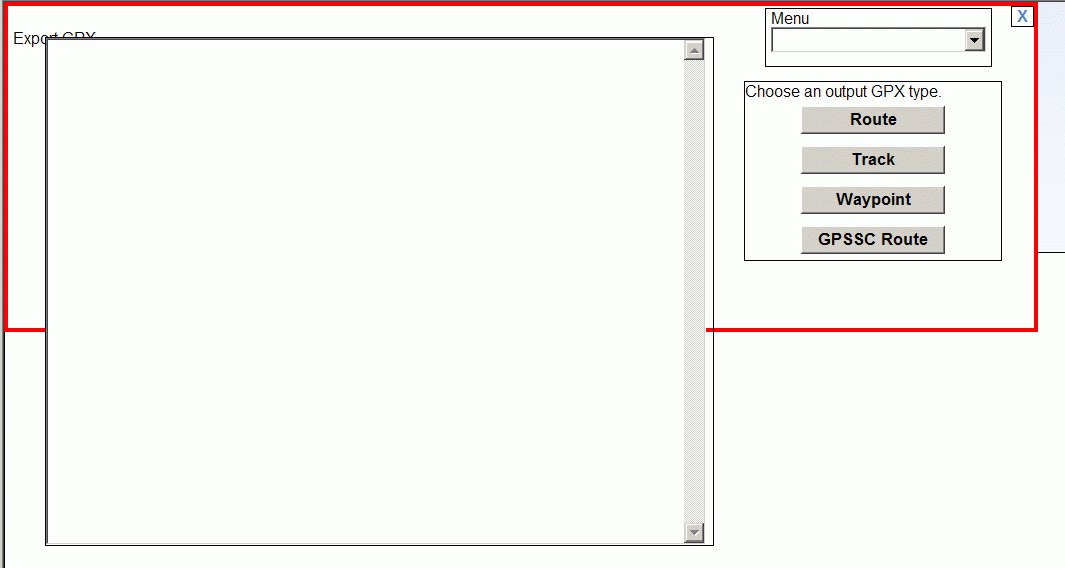
The script lets you:
The script works by extending the functionality of a web page by adding additional JavaScript code. In this particular case it tries to replace the browser display of the web page contents with new contents generated by the additional JavaScript. It does not alter the original web page on it's host server. Scripting in this way allows the API key on the original web page to be re-used to generate a new map with new functionality.
The script adds a dialog window to the top of the web page. I can show some of the dialogs here but can't show any maps because of OS rights etc.
IE might issue a warning that the bookmark on this page could be a security risk. This is because a malicious script might be able to access the original web pages host server in undesirable ways or maliciously extract info that you enter on the original web page. This script does not contain any malicious code but scripts from other sources might. Therefore care should be taken when bookmarking and running scripts to make sure they are not malicious. If you understand JavaScript a good way to do this is to manually check the JavaScript by looking at it's contents. As a general rule bookmarklets are safe on a web site where you do not enter any personal information or create emails. This type of bookmark is known as a bookmarklet for more general information see the two links below.
If you want to look at the JavaScript use these links.
http://www.stevematt.f9.co.uk/osmap/osbookmark.js
http://www.stevematt.f9.co.uk/osmap/xpbookmark.js
http://osgb.ndrw.co.uk/gpx_track/gpx_track.html?test.gpx
http://wtp2.appspot.com/wheresthepath_old.htm note: this web site has a high usage and may run out of map tiles so consider using another. IE only.
http://www.kap.toadstone.com/kapbook/osmap.html
http://monkeyspoon.com/peak-district-mountain-biking-route-map
http://www.electricchili.co.uk/test-map.htm?f=Ordie001.xml
http://www.leechfamily.myzen.co.uk/w-upper-teesdale.htm
http://www.zen180727.zen.co.uk/maps/gaz.html
http://www.pooleharbourheritageproject.org/media/harbourmap.html You will need to set the div size on this page.

When using these JavaScripts with maps hosted on htpps web sites in IE you might see this message.
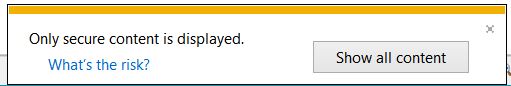
It's because the JavaScripts are on a http web site, click Show all content and try the JavaScript again and it should work. Firefox and Chrome based browsers such as Edge and Opera are likely to block the JavaScripts because of that.
https://www.yorkshirewalks.org/diary06/maps/map196.htm
https://www.walksaroundbritain.co.uk/maps/LiverpoolMap.html
Any web page that has an Ordnance Survey OpenSpace map on it has an API key in it's JavaScript. The OS OpenSpace API matches the key against the web page URL. If they match then your browser can fetch map tiles from the OS map server. See the OS web site for more information on OS OpenSpace.
The script will work with most OS OpenSpace web sites but not all. You may find that some web sites are faulty and do not display the OS map because their JavaScript is not suitable for your browser. In that case the script may still display the map ok because it uses it's own JavaScript. So even if the original web site does not display the OS map it is still worth trying this script. The script will not work with web pages that do not contain an OS OpenSpace API key e.g. those that contain GetAMap maps or jpg images of maps.
These might be of interest to you for their Ordnance Survey map content.
If you want a Google Map version of this web page then click ...Here...
A utility to fix USB GPS jumping mouse problems.
http://www.stevematt.f9.co.uk/FixSerial/fixserial.htm
A Microsoft Silverlight3 SRTM HGT file viewer (shuttle radio topography
mission).
http://www.stevematt.f9.co.uk/sl/srtmviewer.html
Microsoft Edge and the default browser in Android will not allow bookmarks to javascript files to be saved. Instead you need to add a html web page as a bookmark and then edit the URL to point to the javascript file. You might need to reopen Edge for the edit to take effect or maybe refresh the web page a few times. There seems to be a delay before editted URLs come into effect.
In the Chrome version of Microsoft Edge go to Bookmarks and then Manage bookmarks and manually add a favourite using Add favourite.
In the default browser in Android, once you have a bookmark saved you can open Favorites and right click the bookmark and edit the URL.
There is a copy of this web page and script files hosted on a https website here you can use these with maps hosted on https web sites and all websites in Microsoft Edge and other Chrome based browsers.
The javascript URLs are:
OSmap javascript link1:
javascript:(function(){var script=document.createElement('script');script.src='http://www.stevematt.f9.co.uk/osmap/osbookmark.js';document.getElementsByTagName('head')[0].appendChild(script);})()
Download a text file containing the javascript URL. url1.txt

OSmap javascript XP link2:
javascript:(function(){var script=document.createElement('script');script.src='http://www.stevematt.f9.co.uk/osmap/xpbookmark.js';document.getElementsByTagName('head')[0].appendChild(script);})()
Download a text file containing the javascript URL. url2.txt

javascript:(function(){var script=document.createElement('script');script.src='http://www.stevematt.f9.co.uk/osmap/osbookmark10.js';document.getElementsByTagName('head')[0].appendChild(script);})()
Download a text file containing the javascript URL. url3.txt

Last updated 14 November 2020