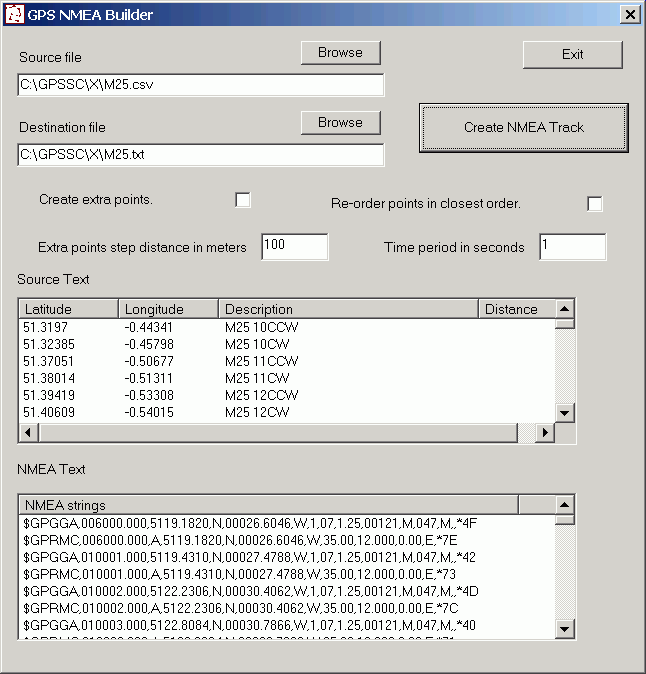
GPS NMEA Builder utility for MS Windows - Creates a set of GPS NMEA $GPGGA
and GPRMC strings from a set of POI (point of interest) co-ordinates.
Download
GPSNMEABuilder.zip 11kb
GPSNMEABuilder.zip

GPS NMEA Builder allows you to create of set of GPS NMEA
strings for a route and save them to a file. You can later use this file to
simulate a GPS. For instance you could use it with a moving map program such
as MS Autoroute, OziExplorer or GPS TrackMaker to simulate travelling a route.
You need a serial Null modem cable or laplink cable to connect two serial ports,
preferable between two PCs although in theory you should be able to use two different
ports on one PC. You supply the route in the form of longitude and latitude
points in a csv text file. You don't need all the points just the main ones,
the program creates the in between points. The program creates only GPGGA and GPRMC
strings. A GPS will normally create others too but for the purpose of simulating
travelling a route this is enough. There are several programs on the internet for sending
GPS NMEA files via the comm ports or you can use my laptop safety
camera detector software GPSSC (see below). On the 'Test' menu select 'Send log file
port'. The latest version of GPSSC (see below) now has an inbuilt 'Replay Log' function which will plot
the course followed in NMEA log and can do the same for the
files created with GPS NMEA Builder with out the need for a second computer.
Notes
The source
file must be in garmin POI csv format. The header line is optional.
eg
;Longitude,;Latitude,;Name,;Details
-5.6824,50.1559,NatTrust The Levant Steam Engine,
-5.5686,50.1325,NatTrust Trengwainton Garden,
You can download POI from various
locations on the internet. Do a search on google for poi, ov2 or ovr.
To use them in GPSSC they need to be in Garmin CSV format. You can download
a free program called PoiEdit from the internet which will convert from many formats
in to Garmin CSV and also has a handy batch convert function.
If you tick the
'Create extra points' box the programs creates one NMEA line for each POI plus extra lines for the path
between each POI.
The minimum time period is 0.001 of a second. If
you are going to create huge lists of NMEA strings it is best to set the time increment
to some thing like 0.1 to prevent the time going past 23:59.
If you tick the
'Re-order points in closest order' box the program will re-order the points in a
linear route. This can take a long time to do if you have thousands of
points. The time it takes the program to create the NMEA strings
depends mainly on the number of POI in your source file. The programs processes
the POI starting with the first POI and then each closest POI. It is the search
for the next closest POI that slows the program when you use it with thousands of
POI. In the unlikely event of having tens of thousand of POI it would probably
be best to split them in to seperate files. The dialog window will not
redraw while it is busy creating the NMEA strings, don't worry about it, it's
normal.
The minimum distance step in the output NMEA strings is
one metre. The reason for this is to avoid problems of poor accuracy and calcution
problems in the program when dealing with very small distances between poi ie 1
to 10 metres. This one metre minimum can result in non straight routes when
POI are very close together.
Other stuff
Fix for Windows jumping mouse problem.
http://www.stevematt.f9.co.uk/FixSerial/fixserial.htm
Laptop safety camera
detector software.
http://www.stevematt.f9.co.uk/ukspeedcamera/gpssc.html
WARRANTY DISCLAIMER
THE PROGRAM AND DOCUMENTATION ARE PROVIDED "AS IS" WITHOUT ANY REPRESENTATIONS OR
WARRANTIES, AND YOU AGREE TO USE THEM AT YOUR SOLE RISK. TO THE FULLEST EXTENT PERMISSIBLE
BY LAW, WE EXPRESSLY DISCLAIM ALL WARRANTIES OF ANY KIND WITH RESPECT TO THE PROGRAM
AND DOCUMENTATION, WHETHER EXPRESS, IMPLIED, STATUTORY, OR ARISING OUT OF COURSE
OF PERFORMANCE, COURSE OF DEALING OR USAGE OF TRADE, INCLUDING ANY WARRANTIES OF
MERCHANTABILITY, FITNESS FOR A PARTICULAR PURPOSE, SATISFACTORY QUALITY, ACCURACY,
TITLE OR NON-INFRINGEMENT.
To the extent that liability may be excluded
at law, we accept no liability for any direct, special, indirect or consequential
damages or any other damages of any kind resulting from the use of any information
or software obtained directly or indirectly from this Site.
We reserve the right to modify, suspend or discontinue, temporarily or permanently,
the Site or any part of it, with or without notice, at any time. You agree that
we shall not be liable to you or to any third party for any such modification, suspension
or discontinuance of the Site.
Governing Law
Use of this Site, including any transfer of information between it and your
own equipment, and these terms and conditions, shall be governed in accordance with
the laws of England and Wales and the English courts shall have exclusive jurisdiction
over any dispute arising out of your use of this Site.
You may not sell this software with out an agreement with us and you may not redistribute
the software although you are welcome to link to this site.

