GPSSC Speed Camera program for MS Windows.
GPSSC is a speed camera warning program that will run
on a MS Windows laptop with a GPS unit attached. The GPS must be able to
send NMEA codes to the laptop comms port, most do but a few might not. The
program gives spoken warnings as you approach each speed camera. It also has other views, one that displays nearby POI (points of interest) ,several route and compass views that operate like a car Satnav and an NMEA track editor view that
can also be used as a Wiki OpenStreetMap OSM or GPX map viewer. You can also display Trekbuddy maps.
GPSSC version 11.0.0.0
12 July 2015.
GPSSC will run in Microsoft Windows versions XP, 7, 8 and 8.1 32bit or 64bit.
gpssc.zip 3.5 Mbyte - see requirements
New in the latest version of the program is a Trekbuddy map viewer. For information on this new feature follow this link ...Trekbuddy view...
The gpssc.zip file contains a 32bit and a 64bit version of the program along with a few sample configuration files and the GPSSC HTML web pages that you find on this web site.
It is best to extract the files to your C: drive so that the files end up in
C:\GPSSC and it's subfolders. You can use 7Zip, Windows Extract all or any other unzip utility.
You also need several subfolders below C:\GPSSC. They are: Voice, POI, Saves,
Routes, GPX, Tracks, Trail and Log. The first two should be created when you unzip the
gpssc.zip file, the others are optional and you will need to create them yourself .
The addition folders are the default locations for files of those types and are
there for your convenience but are not essential.
The gpssc.zip file contains a 2015 OpenStreetMap UK GPSSCCamera.txt speedcam file. If you are upgrading your version of GPSSC you might want to take care not to overwrite your existing file.
The NMEA editor and Trekbuddy viewer and conversion utilities of GPSSC do not care where the program is run from. So if you are only using these parts of the program it is possible to install GPSSC in a different folder or drive. The speedcam part of the program will complain about a missing GPSSCCamera.txt file and you will then need to manually edit the registry and change any references to C:\GPSSC under the key HKEY_CURRENT_USER\Software\GPSSC to your location. Be aware that if you run the Test - Check Registry function in GPSSC this will set all the registry values back to default. It is not recommended to run GPSSC from a different folder as this has not been tested and some of the disk browse buttons have hard coded default folder locations.
GPSSC can import speed camera databases from three different source formats. Magellan, Garmin CSV or the older OV2 format. The latest TomTom OV2 format is not supported.
If you have a newer PocketGPS format database which contains directions, p or t prefixes you should convert the file(s) using the Convert - Convert multi PocketGPS file(s) to CSV menu. The output database file name is C:\GPSSC\GPSSCCamera.txt. There is an option in this dialog to use short camera names. This makes the display of the camera names less cluttered but has the side effect of making the names non unique. If you use short names you can not also use excluded cameras in your routes. The source file format can be CSV or the older OV2 format.
If you have a Magellan format database you can convert the file pocketgps_uk_sc.csv so that it can be used with GPSSC by using the GPSSC Convert - Pocketcamera to GPS CSV file menu. The output database file name is C:\GPSSC\GPSSCCamera.txt .
If you have a garmin csv format database you can convert the file using the GPSSC Convert - Garmin to CSV menu . The output database file name is C:\GPSSC\GPSSCCamera.txt .
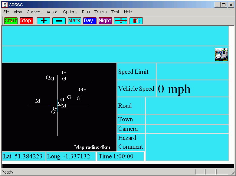
There are various speed camera databases on the https://free-speed-cam-updates.web2diz.net/download/ web site. The Garmin one is the best one to download.Once you have your speed camera database installed you can test it by using the Do a ondraw option from the Test menu. You should see something like the following in which you can see letters representing the speed cameras in the Newbury area. If you choose Action > Manual Location you can move around and see other cameras.
Points to watch
;Longitude,;Latitude,;Name,;Details
-5.6824,50.1559,NatTrust The Levant Steam Engine,
-5.5686,50.1325,NatTrust Trengwainton Garden,
-1.186023,51.668279,A4070,Right turn into lane to Burcot
-1.192873,51.661179,A415,Right turn on to A415 heading west
-1.264974,51.654773,Culham,Left turn heading south
-1.265984,51.645968,?,Turn Right toward Sutton Courtney
-1.313131,51.643870,Drayton,Turn left heading south
-1.314248,51.617757,Steventon,Turn Left towards A34
-1.302751,51.618678,A34, Head South on A34
;To Maidenhead excluding some cameras
:specs:36655@50
:GATSO:643@30
:GATSO:1540@30
:GATSO:1262@30
-1.06548,51.43926,M4 junction 12, continue towards London
-0.97215,51.41287,M4 junction 11, continue towards London
-0.85671,51.43142,M4 junction 10, Continue to junction 8 9
-0.72796,51.49821,M4 junction 8 9, exit and take second exit on roundabout
-0.71209,51.50403,A308M, Take first exit right on to A308 to Maidenhead
-1.186023,51.668279,A4070,Right turn into lane to Burcot
-1.192873,51.661179,:,Right turn on to A415 heading west
-1.264974,51.654773,Culham,Left turn heading south
Menus
File
Open - Opens a GPSSC record file from the C:\GPSSC\Saves folder and loads the track and GPS position from the file. Any existing track will be replaced with the track in the file. The GPS must be stopped if you want to see the map at the GPS position in the file. If the GPS is started the map will move to the current GPS position.
Save - Saves a GPSSC record file to the C:\GPSSC\Saves folder. A record file contains the current track, GPS position and time.
Save As - Saves a GPSSC record file prompting you for a file name.
Print - Prints the current view. This can be the map view, POI view or track editor view. There is no print option for the other views.
Print Preview - Print previews the current view. This can be the map view, POI view or track editor view.
Print Setup - Allows you to select a printer and select printer options.
Exit - Closes the comms port and exits the program.
View
ConvertAllows toolbars or the Status bar to be turned on or off.
Camera Map - Displays the camera position view. This is the default view.
Display POI - Displays nearby points of interest instead of the camera map. Camera detection and audible warnings still work as normal when you have the POI view enabled.
Route - Displays nearby route points and route information instead of the camera map. Camera detection and audible warnings still work as normal when you have the Route view enabled.
Compass - Displays a compass instead of the camera map. Camera detection and audible warnings still work as normal when you have the Compass view enabled.
Pointer - This is a view that combines the Route and Compass views together. It also has a couple of pointer arrows in the middle of the compass. The outer arrow points from your current position towards the next route point. The inner arrow is green and points towards the next route point when you have passed the nearest route point, when you approach the nearest route point it points from the nearest point to the following point and is blue. The outer arrow is coloured red before you reach your first route point and thereafter it is green. To summarise green or red arrows point towards your next route point, the blue arrow points from the next route point to the following route point (i.e. the direction you are likely to go after the next route point).
Trail - This view is similar to Pointer view but has two small compasses and can display your location and trail against a Google map Gpolyline. The route points are displayed larger for easier reading. Click the following link for more information on this view. ...Trail view...
Track Editor - This view is used for editing NMEA tracks or displaying JOSM osm/gpx tracks as a background map. In this view you can extract sections of an NMEA log and save them as new log files. This is intended to be used to extract portions of a large NMEA track. The NMEA tracks can be split or trimmed into smaller sections. This will allow you to select parts of NMEA tracks for upload to web sites such as Wiki OpenStreetMap. Click the following link for more information on this view. '...Track editor...'
Trekbuddy - Display a map from a set of Mobile Atlas Creator Trekbuddy map tiles.
Click the following link for more information on this view. ...Trekbuddy view...
Pocket GPS to CSV file - Converts the Magellan speed camera database to this programs format. The default output file is C:\GPSSC\GPSSCCamera.txt. You can specify the output name if you want to create other camera databases. When you waPocket GPS to CSV file - Converts the Magellan speed camera database to this programs format. The default output file is C:\GPSSC\GPSSCCamera.txt. You can specify the output name if you want to create other camera databases. When you want to use them you will need to rename them to C:\GPSSC\GPSSCCamera.txt You can also use this menu to convert an OV2 format file.
Garmin CSV - Converts a Garmin format csv speed camera database to this programs format. The default output file is C:\GPSSC\GPSSCCamera.txt as above. You can also use this menu to convert an OV2 format file.
Convert PocketGPS file(s) to CSGarmin to CSV file - Converts a Garmin format csv speed camera database to this programs format. The default output file is C:\GPSSC\GPSSCCamera.txt as above. You can also use this menu to convert an OV2 format file.
Convert multi PocketGPS file(s) to CSV - Converts a Garmin format CSV file(s) speed camera database to this programs format. It also removes direction, p or t prefixes from the camera names. The default output file is C:\GPSSC\GPSSCCamera.txt as above. You can also use this menu to convert an OV2 format file. There is an option in this dialog to use short camera names. This makes the display of the camera names less cluttered but has the side effect of making the names non unique. If you use short names you can not also use excluded cameras in your routes.
GPX Route to Route CSV - Converts a GPX route file to this programs route format. This is mainly intended to be used with the Marengo Route Creator web site where you can easily create a route and download it in their GPX format. It will also support some other GPX files from other sites. The source file will contain route information in this format. ‹wpt lat="51.426527" lon="-0.898195"› ‹name›SU7670‹/name› ‹desc›SU7670 : Mill Lane, Sindlesham‹/desc› . I've tried it with files from the following sites. tor - http://www.marengo-ltd.com/map/
My Googlemap .gpx route or track uploader and creator web page.
http://www.stevematt.f9.co.uk/googlemap/iegmap.html
GPX Track to Route CSV - Converts a GPX track file to this programs route format. The source file will contain track information in this format. ‹ trkpt lat="54.148832" lon="-2.295177"› ‹ /trkpt›
To make a GPSSC route file using Google map directions use my Googlemap web page:
http://www.stevematt.f9.co.uk/googlemap/iegmap.htmlNMEA log to track or route GPX - Creates a GPX file from a GPSSC NMEA log file.
JOSM GPX to map project - Creates a GPSSC track project from a GPX track file. This creates a track project file and a set of NMEA files for use in the NMEA track editor. It was originally intended to convert Josm GPX files to a track project that you could then add your own NMEA tracks to but this became unneccesary when I added the option to directly import a GPX or OSM XML into the track editor. However I have found it useful for converting tracks from my old Garmin 12 GPS. The GPSBabel program can retrieve tracks from a Garmin and convert to NMEA but I found the NMEA format was unusable. Instead I use GPSBabel to retrieve a track from the Garmin as a GPX file and then us the GPSSC JOSM GPX to map project function to convert the GPX into a set of NMEA files. I can then edit the NMEA tracks in the track editor before converting back to GPX format for uploading to Wiki OpenStreetMap. If you use this method you need to have the Garmin track record method set to fill rather than wrap. This ensures the track points are sequencial. s memory when loading and are quicker to load. You can export a GPX directly from Josm but if you want to have the tracks colour coded in GPSSC then you need to use the GPSSC convert menu. Part of the OSM to GPX process is to copy the OSM tags into the GPX track name. You can manually make a larger single map if you copy several GPX files into one larger file and that will still load ok in GPSSC. OSM files exported from Merkaartor do not work in GPSSC because GPSSC expects tracks to be on separate lines (for a fix see Add new line pairs below).
Big OSM to GPX track - Converts an Wiki OpenStreetMap OSM from their web site or Josm program into an multitrack GPX track file. This is the same as the OSM to GPX track menu but is designed to be used to extract an area from a large OSM file. You can specify the boundaries of the area to extract. You can download Big OSM to GPX track - Converts an Wiki OpenStreetMap OSM from their web site or Josm program into an multitrack GPX track file. This is the same as the OSM to GPX track menu but is designed to be used to extract an area from a larger OSM file. You can specify the boundaries of the area to extract. You can download an OSM of the UK from http://nick.dev.openstreetmap.org/downloads/planet and then use this menu to extract smaller map areas from it. In practice it is possible to extract areas up to one degree of latitude and longitude. These can take anything from a few minutes to a couple of hours to extract depending on how many nodes are in the area. Coordinates are entered in decimal format not degrees, minutes, seconds e.g. 51.10481. The Translate unicode characters tick box translates unicode pairs in the range 0xC380 - 0xC3BF to ascii codes 0xC0 - 0xFF. This allows characters such as the ß in the german word straße to be displayed correctly when you use the GPX in the NMEA track editor view.
Add new line pairs - Adds a new line character pair to a file after each </trkpt> <trk> </trk> </name> <trkseg> </trkseg> />. This allows files from sources which have lots of things all on one line to be used in GPSSC. For example GPX track files from GPS TrackMaker and OSM files from Merkaartor.
SRTM HGT to GPX track - Converts a SRTM Shuttle Radar Topography Mission file (height file) to a GPX track file that you can load and view in track editor view. This doesn't work as well as I would have liked. The resulting gpx contours are zig zaggy and broken into separate segments but as long as you don't zoom in too far they are ok. They look a bit odd, a bit alien arty. You can only use the three arc second files, not the US area higher definition ones. Make sure you unzip the SRTM files after downloading before using them. The resulting gpx are fairly large and take a few minutes to load into the track editor.
Fast OSM to GPX track file - This is the same as the Big OSM to GPX track menu and converts an OSM file into a GPX track file. It is optimised for quicker conversion and is much quicker than the other menu but is limited to a maximum of two millions nodes in the output GPX file. That's not really a problem because if you use a larger than that GPX in the GPSSC Track editor you'll find it takes ages to load.
Extract Speedcams from an OSM file - Allows you to extract all the speed cameras in an OSM file and write them out to another file in iGo or GPSSC format. You can get an OSM of all the UK from http://download.geofabrik.de/europe/great-britain.html the direct link to the OSM file is great-britain-latest.osm.bz2. Unzip the file using 7zip and use it as the source file. It will take about ten minutes for the speed camera file to be created.
For more info on OSM speed cameras see Speedcams.
Action
Mark Location - Saves the current GPS location in the file C:\GPSSC\MarkedSpots.txt.You can also use the Mark button on the toolbar to do this.
Log NMEA Data - Allows you to record and save all the GPS NMEA data to a file.
Mute - Turns the sound off or on. You can also use the Mute button on the toolbar to do this.
Select Poi Files - (Point of interest) POI files downloaded from the internet tend to be in files by subject. This menu allows you to select which POI files you currently want to use. You can only select POI files which are in your C:\GPSSC\POI folder. As a general rule it is best to only select a few at a time because the program searches through the files every 30 seconds to find POI that are local to your current position. If you select dozens of POI files then the program is going to be very busy processing them.
Near Poi List - When the POI view is enabled this shows a list of nearby POI. This is handy because if you have many POI on the map view they can be on top of each other and difficult to read.
Near Camera List - Lists the cameras that are in the current map area.
Route Excluded List - List the cameras that are excluded by the loaded route.
Route Point List - displays the points in the loaded route file.
Route Picker - Contains a list of favorite routes that can be quickly selected with numeric keys or mouse. To add or select another route, click on the Change button on the right of line. The letter R on the keyboard also opens the Route Picker.
Manual Location - Lets you set a manually location or scroll up or down the map. This is used to view the map outside of your current location. Make sure GPS communications are stopped before using this otherwise the map just jumps back to your current location. Restart GPS communications once you are done.
Select Route File - Select and open a route file. When the Route view is enabled points of your route will be displayed on the map. The name of the last route file used is saved in the registry so that it can be automatically loaded when using autostart.
Options
Auto start - Items that are ticked will auto start when the program is run.
- GPS communications, opens the comms port and reads the GPS NMEA strings (same as clicking the Start button).
- Size window, resizes the program window to 800 by 600.
- NMEA log, creates a new log file each time you start GPSSC and records all the GPS NMEA strings to it.
- Load route, loads the last route that you manually loaded, your route file must be in the C:\GPSSC\Routes folder.
Comm Settings - This is where you set the port settings for your GPS. Must be set to the same as your GPS. Best set to lower speeds 4800 or 9600. If your GPS supports various interface protocols make sure it is set to NMEA.
Speed - The GPS reports current speed in knots. It can be displayed as miles per hour, knots or kilometres per hour.
Map scale - Sets the area covered by map and more importantly the area that is monitored for speed cameras. A map scale of 4km gives good results. This can be set lower if you are driving in town at lower speeds and higher for fast motorway speeds. You can also use the plus and minus buttons on the toolbar to change the maps scale. A minimum area of 4km is monitored for cameras regardless of the zoom setting.
Route - Allows you to set which columns in your route file are displayed on the map. A '*' is all ways displayed for each route point on the map. In addition you can also display the following. Point number, the line number of the point in the route file. Text 1 (columns 3). Text 2 (column 4).
Route Speech Options - Choose a Speak Timing mode. The waypoint texts are spoken twRoute Speech Options - Choose a Speak Timing mode. The waypoint texts are spoken twice as you approach each waypoint. The trigger distances are 1200m and 400m in Motorway mode, 600m and 300m in Country mode and 500m and 150m in town mode. If you are using Town mode then the waypoints need to be accurate otherwise you might not get the 150m trigger because you do not get closer than 150m to the waypoint. The actual distance spoken is the distance to the waypoint when GPSSC sent the text to the agent. By the time the agent has finished speaking you may have travelled some distance past that point. When waypoints are close together the first trigger point will be the mid distance between the previous and next waypoint. So for example if you were in Motorway mode and you have two waypoints set which are 500 metres apart and you want to leave at the second one, you will only get the text for the second waypoint spoken when you are 250 metres from it. In which case you should consider putting text for the second waypoint also on the first waypoint. You can also add addition waypoints for additional spoken text, e.g. add a waypoint 3000 metres before your desired exit saying for example "Continue past next exit and exit at junction 10".
Scr = 800*700 - Sets the program window size to 800 * 700. This is large enough for all the screen info to be displayed including the NMEA sentences at the bottom of the window. This is useful if you want to size the edges of the program window outside of the visible screen. y.
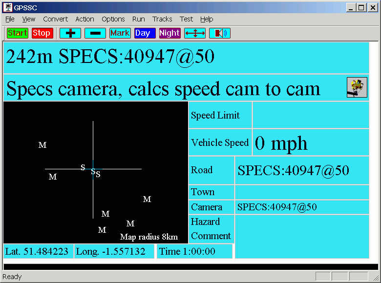
Specs average speed - Calculates your average speed between specs cameras. When you leave a specs area and no specs cameras are on the map the average speed is cleared. You can also clear/reset or start the specs display manually by using the space key.
Track Logging - Records a list of previous position co-ordinates and displays them on the map as a travelled track. This gives a indication on the map of the route travelled against the positions of the speed cameras. This is a temporary log and the track is not permanently saved to disk. Set the track length to a lower value for low spec laptops. Changing the track length clears the current log. Switch off track logging for bottom spec laptops.
Start Time - Allows you to choose routes and the night display colours when GPSSC starts between specified times. For example you can use this to automatically load one route when you travel to work and another when you return home.
Time Zone - The GPS gives the time as GMT. Enter your time offset in hours to display local time.
Colours - Allows you to choose two colour schemes, one for day use and one for night use.
Use day colours - uses the day colour scheme, this can also be set by using the day button on the toolbar.
Use night colours - uses the night colour scheme, this can also be set by using the night button on the toolbar
Run
Start - Starts the program by opening the comm port and reads the GPS NMEA data. You can also use the Start button on the toolbar.
Stop - Closes the comm port and stops monitoring the GPS. You can also use the Stop button on the toolbar.
Tracks
The Tracks menu is for use in the Track Editor View mode. This view is used for editing NMEA tracks or displaying JOSM osm/gpx tracks as a background map. For an example screen shot and instructions for this view click ' here'
Trail
Trail lets you use a Google map Gpolyline as a trail in the Trail View mode. You can create a Gpolyline while creating your route file on the web at 'http://www.stevematt.f9.co.uk/googlemap/iegmap.html'
Trekbuddy
Trekbuddy viewer. Displays a Trekbuddy map. For information on this new feature follow this link ...Trekbuddy view...
You can start the Trekbuddy viewer by using the View menu and Trekbuddy. Options and printing for the Trekbuddy view are under the Trekbuddy menu.
Test
Do a ondraw - Processes a dummy test NMEA string and displays the result. The window size must be set to at least 800 * 700 to show everything.
Check Registry - Creates any missing registry entries and sets all options to defaults. You only need to run this if you want to set everything to defaults. Normally you would not need to run this because the registry entries are created the first time you run the program. There is no un-installer for this program, if you don't like the program you might want to manually remove the registry entries by using the windows registry editor. You need to delete the key HKEY_CURRENT_USER\Software\GPSSC.
Load camera file - Manually loads the near camera list. When a GPS is connected this list reloads automatically every thirty seconds. If you disconnect a GPS and change the map area you can manually load the camera file to update the displayed cameras. You must have a current location before the near camera list can load.
Get distance to a location - Calculates the distance between two locations in kilometres.
Send log file to port - Sends a set of NMEA strings to the comms port. If you record your GPS NMEA output to a text file using using the Action > Log NMEA Data menu or from another program and you have a second PC you can send the file from one PC to another PC running GPSSC to simulate having a GPS attached. Normally you would need a Null modem or laplink cable to connect the two PCs. If GPSSC has been started then you must click Stop so that the comms port iSend log file to port - Sends a set of NMEA strings to the comms port. If you record your GPS NMEA output to a text file using using the Action > Log NMEA Data menu or from another program and you have a second PC you can send the file from one PC to another PC running GPSSC to simulate having a GPS attached. Normally you would need a Null modem or laplink cable to connect the two PCs. If GPSSC has been started then you must click Stop so that the comms port is closed before you can use this utility.
Speak a test phrase using the route voice - Lets you listen to some sample text to check that your sound is working .
Create passed camera list - Creates a list of passed cameras from an NMEA log file. Displays your speed at passed cameras from an NMEA log file. The primary use of this function is to aid in creating a list of excluded cameras for a route file. For example if you are regularly travelling a certain route you can save the GPS NMEA sentences to a NMEA log file. This file can then be used to create a list of cameras along the route. I.E. By searching for cameras that are more than 300 metres from your route you can then exclude these from your route and prevent warnings for them. You can copy paste this list into your route file. By setting the nearest distance to 0 you can also get your speed for the nearest GPS position to each passed camera. When copy pasting to your route files only copy paste the camera names e.g ':MOBILE8093@30' do not incude the additional information such as the distance and passing speed. If you are using routes with excluded cameras it is also a good idea to have a copy of the route in the Route Picker without the excluded cameras in case you unexpectedly need to divert off route and want to be able to quickly re-enable the excluded cameras.
Replay a log file - Replays a journey from an NMEA log file.
Snap to route - Sequences through the points in the currently selected route file setting the map position to each point in turn. This brings the route into view on the map. This is intended to make it easier for you to see the route points layout on screen after you have created a new route. You will need to have your GPS stopped or disconnected to prevent the location jumping back to your GPS position.
About - Displays version and purchasing information.
Shortcut key list - Displays a list of shortcut keys and their assignments.
Other things
My Googlemap .gpx route or track uploader and creator web page.
http://www.stevematt.f9.co.uk/googlemap/iegmap.html
My Ordnance Survey maps javascript bookmarklet. Allows you to import/export GPX files on Ordnance Survey map web sites.
http://www.stevematt.f9.co.uk/osmap/osbookmark.html
Fix for Windows jumping mouse problem. This is handy if you are using a USB GPS. Especially if you plug your GPS into several ports.
http://www.stevematt.f9.co.uk/FixSerial/fixserial.htm
GPS NMEA Builder utility for MS Windows - Creates a set of GPS NMEA $GPGGA strings from a set of POI (point of interest) co-ordinates. Useful for simulating the $GPGGA strings a GPS would create for a route.
http://www.stevematt.f9.co.uk/ukspeedcamera/GPSNMEABuilder.html
WARRANTY DISCLAIMER
THE PROGRAM AND DOCUMENTATION ARE PROVIDED "AS IS" WITHOUT ANY REPRESENTATIONS
OR WARRANTIES, AND YOU AGREE TO USE THEM AT YOUR SOLE RISK. TO THE FULLEST
EXTENT PERMISSIBLE BY LAW, WE EXPRESSLY DISCLAIM ALL WARRANTIES OF ANY KIND WITH
RESPECT TO THE PROGRAM AND DOCUMENTATION, WHETHER EXPRESS, IMPLIED, STATUTORY,
OR ARISING OUT OF COURSE OF PERFORMANCE, COURSE OF DEALING OR USAGE OF TRADE,
INCLUDING ANY WARRANTIES OF MERCHANTABILITY, FITNESS FOR A PARTICULAR PURPOSE,
SATISFACTORY QUALITY, ACCURACY, TITLE OR NON-INFRINGEMENT.
To the extent that liability may be
excluded at law, we accept no liability for any direct, special, indirect or
consequential damages or any other damages of any kind resulting from the use of
any information or software obtained directly or indirectly from this Site.
We reserve the right to modify, suspend or discontinue, temporarily or
permanently, the Site or any part of it, with or without notice, at any time.
You agree that we shall not be liable to you or to any third party for any such
modification, suspension or discontinuance of the Site.
Governing Law
Use of this Site, including any transfer of information between it and your
own equipment, and these terms and conditions, shall be governed in accordance
with the laws of England and Wales and the English courts shall have exclusive
jurisdiction over any dispute arising out of your use of this Site.
You may not sell this software without an agreement with us and you may not
redistribute the software although you are welcome to link to this web site.
Last updated 23 February 2020.